

Bangalore, the Silicon Valley of India, has witnessed remarkable urban growth over the past two decades. With this rapid expansion, the need for efficient public transportation has become paramount. The Bangalore Metro has emerged as a vital lifeline, significantly easing the city’s commuting woes. Bangalore Metro route map to navigate the network with ease and efficiency.
Bangalore Metro: An Overview of the Lifeline
The Namma Metro, officially known as the Bangalore Metro, is operated by the Bangalore Metro Rail Corporation Limited (BMRCL). It offers a fast, reliable, and comfortable commute, connecting key areas across the city. With its ever-expanding network, the metro has become a preferred mode of transport for daily commuters, reducing travel time and decongesting Bangalore’s notorious traffic.
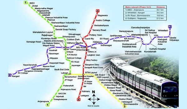
Bangalore Metro Route Map: Lines and Stations
The Bangalore Metro route currently consists of two primary lines, with several extensions and new corridors under construction. The network operates with modern infrastructure, ensuring safe and timely travel.
Purple Line: East-West Connectivity
The Purple Line serves as the backbone of the Bangalore Metro network, linking Whitefield in the east to Challaghatta in the west. This line connects major residential, commercial, and IT hubs, making it a preferred route for professionals and daily commuters.
Key Stations on the Purple Line:
-
Whitefield
-
KR Puram
-
Baiyappanahalli
-
Indiranagar
-
MG Road
-
Majestic (Interchange Station)
-
Vijayanagar
-
Mysuru Road
-
Challaghatta
Green Line: North-South Corridor
The Green Line enhances connectivity between Nagasandra in the north and Silk Institute in the south. This route passes through densely populated residential and commercial areas, providing seamless travel options for daily commuters.
Key Stations on the Green Line:
-
Nagasandra
-
Peenya
-
Yeshwanthpur
-
Rajajinagar
-
Majestic (Interchange Station)
-
Lalbagh
-
Jayanagar
-
Banashankari
-
Silk Institute
New Lines and Future Expansions
Bangalore Metro is rapidly expanding with multiple phases under construction. The upcoming lines will offer greater connectivity to the city’s outskirts and emerging business districts.
Yellow Line: Connecting RV Road to Bommasandra
The Yellow Line is one of the most anticipated metro routes, aiming to connect the IT corridors in Electronic City to the southern parts of the city. This line will enhance commuting efficiency for tech professionals.
Pink Line: Linking Kalena Agrahara to Nagawara
The Pink Line, part of Phase 2, will stretch from Kalena Agrahara to Nagawara, passing through key residential and commercial zones. Once operational, this line will significantly reduce travel time between north and south Bangalore.
Blue Line: Connecting Central Silk Board to KR Puram
The Blue Line will link Central Silk Board to KR Puram, creating a vital corridor for tech parks and business zones. This line will connect with the Purple Line at KR Puram, streamlining the commute.
Interchange Stations: Smooth Connectivity Across Lines
Bangalore Metro features key interchange stations where passengers can switch between lines, enhancing travel flexibility.
Major Interchange Stations:
-
Majestic: Connects the Purple and Green Lines.
-
KR Puram: Will serve as a vital interchange for the Purple Line and the upcoming Blue Line.
-
Jayadeva Hospital: Future interchange point for the Yellow and Pink Lines.
Bangalore Metro Timings and Frequency
The Bangalore Metro operates with punctuality, offering frequent services during peak hours.
-
Weekday Timings: Trains run from early morning to late evening, ensuring reliable travel throughout the day.
-
Weekend and Holiday Timings: Slightly modified schedules offer convenience for leisure travelers.
-
Frequency: Trains arrive at intervals of a few minutes during peak hours, minimizing wait times.
Bangalore Metro Fare System and Smart Cards
Commuting via Bangalore Metro is both economical and efficient. The fare structure is designed to offer affordability while maintaining high service standards.
Smart Card Benefits:
-
Cost-Effective Travel: Frequent commuters can benefit from discounted fares with metro smart cards.
-
Contactless Payment: Smart cards reduce the hassle of ticketing queues and enable quicker entry and exit.
Last-Mile Connectivity Options
To enhance the commuter experience, Bangalore Metro offers seamless last-mile connectivity through various transportation options.
Feeder Bus Services
BMTC (Bangalore Metropolitan Transport Corporation) operates feeder buses, connecting metro stations to nearby residential and commercial areas. These buses bridge the gap between metro stations and end destinations.
Auto-Rickshaw and Cab Services
Dedicated auto and cab stands are available at most metro stations, providing easy access to surrounding areas. Ride-hailing services also operate around metro stations, offering convenience to passengers.
Benefits of Using Bangalore Metro
The Bangalore Metro offers numerous advantages, making it a preferred mode of transport.
Reduced Travel Time
Metro services significantly cut down travel time, especially during peak hours, offering a faster alternative to road travel.
Eco-Friendly Transportation
With electric-powered trains, the metro promotes sustainable commuting, reducing the city’s carbon footprint.
Enhanced Safety and Comfort
Metro stations and trains maintain high safety standards with CCTV surveillance, security personnel, and emergency assistance. Clean, air-conditioned coaches offer a comfortable travel experience.
Tips for a Hassle-Free Metro Commute
-
Use Smart Cards: Avoid long queues by opting for prepaid smart cards.
-
Plan the Route: Refer to the Bangalore Metro route map before starting your journey for better route planning.
-
Travel During Off-Peak Hours: To avoid crowd congestion, plan travel during non-peak hours.
-
Stay Informed: Keep track of metro service updates, especially during expansion phases, for a smoother commute.
Bangalore Metro’s Impact on Real Estate and Infrastructure
The expansion of the Bangalore Metro has significantly influenced the city’s real estate market. Areas with metro connectivity have seen a rise in property value, making them prime investment destinations. Improved accessibility has also boosted commercial growth along metro corridors.
Conclusion
The Bangalore Metro route map continues to evolve, transforming the city’s commuting landscape. With expanding corridors, enhanced last-mile connectivity, and future-ready infrastructure, the metro offers a reliable, efficient, and sustainable transportation solution. Contact us to learn more about Bangalore’s real estate trends and explore metro-connected properties.
Frequently Asked Questions
-
What is the Bangalore Metro route map?
The Bangalore Metro route map displays the entire metro network, showing all operational and upcoming lines, stations, and interchange points. It helps commuters plan their travel efficiently. -
How many lines does the Bangalore Metro currently have?
The Bangalore Metro currently operates with two primary lines: the Purple Line (East-West) and the Green Line (North-South). Several new lines are under construction, including the Yellow, Pink, and Blue Lines. -
Which stations are the major interchange points?
The key interchange stations include:-
Majestic: Connecting the Purple Line and Green Line.
-
KR Puram: A future interchange for the Purple Line and the upcoming Blue Line.
-
Jayadeva Hospital: A future interchange for the Yellow and Pink Lines.
-
-
What are the Bangalore Metro timings?
The Bangalore Metro operates from early morning to late evening. During weekdays, trains run frequently during peak hours, while weekend schedules offer slightly modified timings. -
How can I get the Bangalore Metro route map?
You can access the Bangalore Metro route map online on the official BMRCL website or through metro station information boards. Various navigation apps also display real-time metro routes and timings. -
What are the payment options for Bangalore Metro tickets?
You can purchase metro tickets through:-
Single journey tokens at ticket counters or vending machines.
-
Smart cards for frequent travelers, offering cashless and discounted travel.
-
Namma Metro mobile app for digital ticketing.
-
-
Does the Bangalore Metro offer last-mile connectivity?
Yes, BMTC feeder buses, auto-rickshaws, and ride-hailing services offer last-mile connectivity from metro stations to nearby residential and commercial areas. -
Are there parking facilities at metro stations?
Several Bangalore Metro stations offer parking facilities for two-wheelers and four-wheelers, making it convenient for commuters using personal vehicles. -
Is the Bangalore Metro expanding to new areas?
Yes, the Bangalore Metro is expanding under Phase 2 and Phase 3. New lines such as the Yellow, Pink, and Blue Lines will enhance connectivity across the city, including IT hubs and peripheral areas. -
Is the Bangalore Metro safe for solo travelers?
Yes, the Bangalore Metro prioritizes passenger safety with CCTV surveillance, security personnel, and well-lit stations. It offers a safe and reliable commuting experience for solo and late-night travelers.


